Categories
CDT CO Section 1 CDT WY Section 6

Day 128: Near the CO/WY Border

When I woke up at 3:50am, I could see the flashing of distant lightning and eventually the sound of distant thunder. It was clear a storm would arrive by the time I could get packed up, so I decided to sleep in until it had passed.

It took most of an hour for the rain to start, and I got in a little more uncomfortable sleep. But little did I know that that first storm would be followed by 5 more in sequence, with never more than a half-hour respite in the rain or hail between them. I did as much packing and prep as I could do from under cover of my rainfly, including wiping up all the water that had gotten inside during the storms. Then I just watched some videos I had downloaded to pass the time.

Finally, during the 9 o’clock hour, there was a long enough cessation of rain to get the tent down and everything packed without getting soaked. No sooner had I gotten my rain gear on and started hiking, a little after 10, than it started hailing again. With the cold wind blowing over those rocky hilltops, I very quickly lost feeling in my fingers and had to pull them into my Packa sleeves. It barely helped.

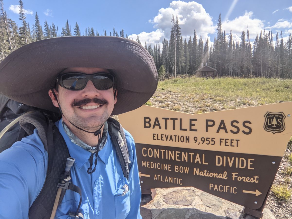
A mile down the trail, the hail had stopped, the rain lightened. I passed Cliff and Lost sitting beside the trail looking a little bit soaked and muddy. They indicated they were planning to do the road walk detour to Steamboat Springs to try and get to Mt. Elbert (some 365 miles sobo from there) before the snows came. I wouldn’t be seeing them in the Zirkels. At my pace, I don’t have much hope that Elbert will be safe to climb by the time I would pass it.

Anyway, they must have chased me over the rocky hilltops with indistinct trail for the next couple of miles as the sun finally came out and warmed up the day enough that I could feel my fingers again because as soon as I stopped to take my Packa off and put my hat on, they passed me never to be seen again. I wasn’t even trying to catch them. As I had lost most of the morning to waiting out the endless rain, I had given up hope of doing much more than getting into Colorado this day.

I took a nice break on a rock shaped like a chair a mile or so later. A couple of hours after that, I took my normal lunch break on top of a hill scattered with uncountable blowdowns. After losing the trail for a quarter mile following a missed turn and backtracking, I took my regular dinner two hours after that on the edge of a very boggy meadow.

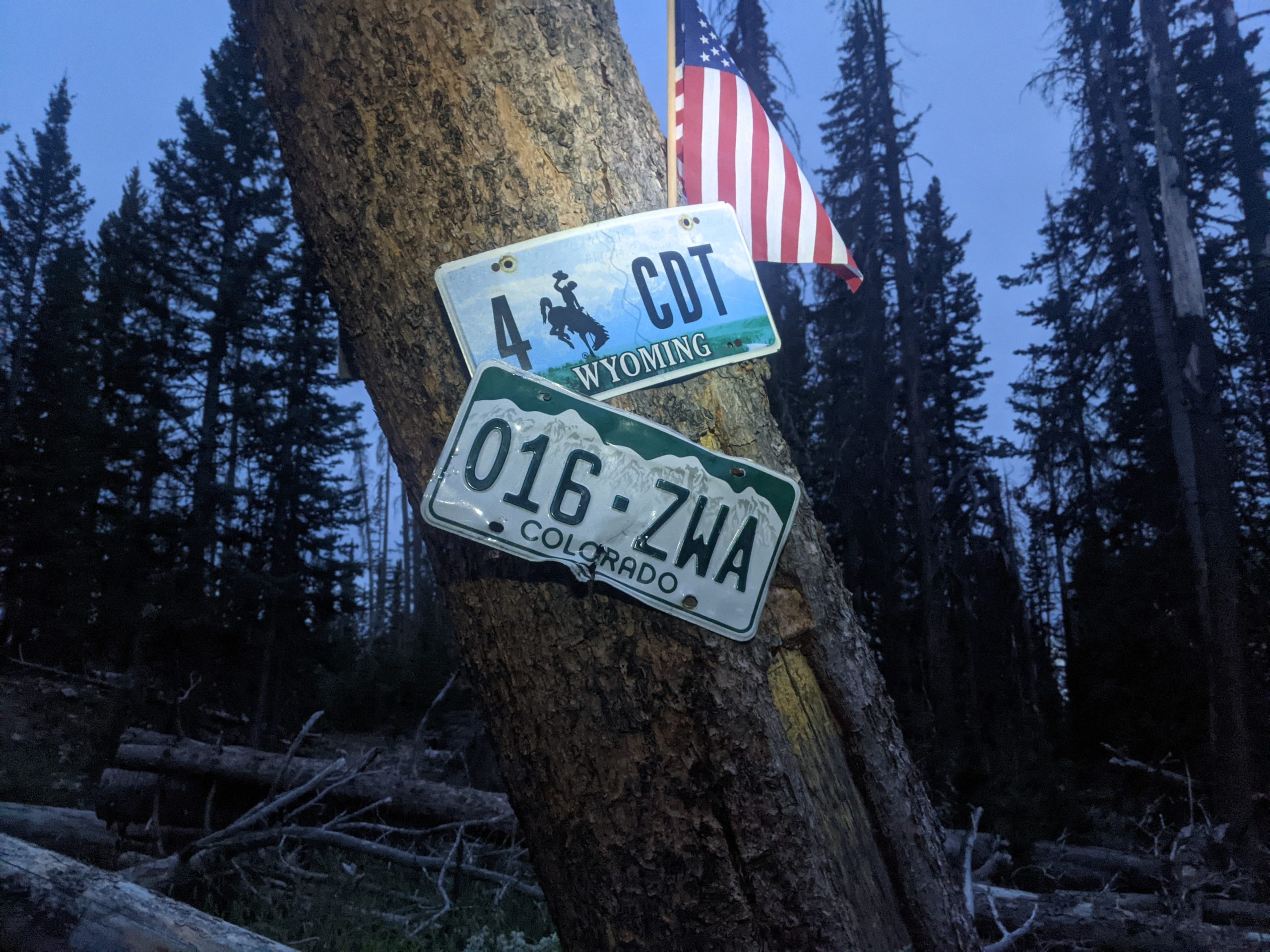
I carried some water out of a nice stream there and climbed up to another meadow, where I scared off a dozen elk at very close range when I popped around a corner and they spotted me last second. They disappeared into the forest at light speed, but looked very elegant doing it. A while later, a half hour after sunset, I crossed the border into Colorado. There are five states on the CDT, and I had now hiked it in all of them. Bingo!

A third of a mile down the hill from there, I finally found a levelish spot with few enough rocks and tufts of high grass to pitch a tent on, and did just that in the dark. Shortly after getting everything that needed to be dry under the tent, the last rain of the day came through, a very light and pleasant affair accompanied by some strong, cold winds.

Colorado would seem to be a place with a lot of trees, a lot of blowdowns, high elevation (as I hadn’t been below 9000 feet all day just getting into it), cold winds, and temperamental weather. But the forecast for the next day indicated it would be sunny, clear, and ideal for making a few more miles.

Trail miles: 13.4

Distance to Steamboat Springs: ~88 miles

Categories
CDT WY Section 6 Uncategorized

Day 127: South of Green Mountain

With all the sound and light and the slightly canted tentsite, it was easy to wake up when everyone around was getting ready to leave. Sunday morning in an RV park: guaranteed mass exodus.

But I had been up until midnight. I didn’t want to get up yet. I couldn’t get back to sleep, so I ended up lying about in the tent chatting online for a couple of hours. Just long enough for the grocery store next door to open.

When I did finally leave the tent, I took my phone to the laundry to charge and then hit up the grocery for breakfast. Coffee, energy drink, choccy milk, Gatorade, two breakfast sandwiches and a burrito. I carried it all back to the laundry and ate it all (except the Gatorade which I saved for a couple of hours and slowly sipped for a few hours) while watching three consecutive episodes of Craig of the Creek on the TV in there. You have to pack all the pleasures of civilization in while you have the chance.

After a morning bathroom break, I spent an hour or so in my tent sewing up rips in my shirt and shorts (including that hole in my pocket I’ve been putting off fixing for several weeks since I acquired a replacement needle). Then it was time to pack up. Most of the campground had emptied out already. So I took my pack over to the one nearby picnic table that had direct sunlight to dry. That became my central packing point. I rolled out my mattress on it. Everything got moved there. And by the time I was packed up, everything was mostly dry just in time for the trees to steal the sunlight.

I finished packing shortly after the Bear Trap Cafe opened again. Time for one more big meal before hitting the trail. And their good wifi helped me get all my posts uploaded shortly after I finished my meal (of fish tacos, a Cuban sandwich, and tots).

As soon as I left, I walked to the end of the road to the highway and started walking toward Encampment sticking my thumb out at each passing truck. The highway went two miles through Encampment before heading up the 12 miles back to Battle Pass, and I preferred not having to walk all the way to the other side of town to get a hitch. I got pretty lucky despite the sparse traffic. A truck came up to me just as I had crossed the Encampment city limits. Lauren said she would give me a lift to the pass as soon as she went to pick up a bed for her friend’s disabled child. So I just offered to help her move and load the bed and she agreed.

So here’s all the details: I’m the second person this woman (who is my age) has ever given a lift to, she’s not going anywhere near the pass otherwise, her husband’s far away jumping fires, and she’s taken out this old former fire truck and never drives that gets horrible gas mileage just to move this bed for her friend’s child, and decides based entirely on my hat and mustache that she is willing to drive this truck miles out of her way for me. Honestly, helping her with the bed was the least I could do. So we find the house with the bed frame ready to go, and the brother of the guy who is giving it away helps us too by fetching out the box spring and mattress and wrangling an overly excited dog into the house. We Tetris all the bed parts into the bed of the truck and run a chain across it. And then, with all that in the back, she drives me to the pass. It’s like 2:30 pm when she leaves me.

At this point, I remember that I didn’t download any maps for the alternate trails around the Morgan Creek Fire closure. The trailhead has excellent 4G service (much better internet than anywhere in Riverside by far), so I end up hanging around for another hour at the trailhead just downloading what I need to continue. Luckily, I was able to multipurpose the wait thanks to the privy in the middle of the parking area, saving some time down the trail.

It was a little after 4 when I finally started hiking. The trail was similar to what it had been in the last hours of the previous day, rocky road into rocky trail through forest. Eventually, it become more of a dirt and mud and grass trail through boggy meadows crossed by multiple muddy streams. I crossed some on logs where I could tell the mud would be up to my ankle if they weren’t there.

After a mile of this, I found a nice rock in the shade to stop for supper. There was a nonstop cold wind that cooled my pot too quickly and made the pasta in my rice a little too gummy. It also made me shiver a bit. I was happy to get back on the trail.

No sooner had I than I spotted two hikers behind me. I assumed Jennifer and Deluxe. I used them as motivation to keep moving even when the trail got rocky, steep, and passed through blowdowns. The trail came over a series of rocky hilltops where it was easy to lose as the sun was setting, and then joined a ridgeline with a long view. It was dark enough I was ready to stop, and I found a perfect flat spot just off the trail. No sooner had I started unpacking than the pair came up behind me and passed. It was actually Cliff Richards and Lost Keys, finally caught up.

I had no idea what the other sobos around me had planned with regard to the closure, which started only a day’s walk from here. If they went a different way, they were likely to beat me to Steamboat, and then who knows who I would be hiking with. That’s motivation to get an early start right there.

Trail miles: 7.5

Distance to Steamboat Springs: ~93 miles