I didn’t need to hurry, so I didn’t start hiking until well after 8.
The hike was pretty much exactly the same as it was the last time I hiked it. Nothing new or interesting to report. Some twisted dirt road, some small hills, some gates, and eventually joining a dirt road where I neither continued onto the official CDT route (which I’ve never taken because it looks boring and pointless) nor went right down the dirt road to Aragon Well (like I did last year), but instead went left and followed the road directly out to New Mexico Highway 12.
I was looking to get a hitch to Reserve to get some lunch, but there was very little traffic in that direction. I walked down the highway a little until I was at the road’s high point, and dropped my pack on the hillside. There was no shade, so I sat in the sun next to a very noisy cicada on the hillside where I could see half a mile down the road. Every ten minutes or so, a truck or two would come into view, and I’d step up next to the road and stick out my thumb.
I woke with the birds at 5:30 and felt fully-rested this time. Even with moving slowly and taking some time to sew up a hole in my glove, I was still moving up the trail by 7:15.
After a half mile, I was at the junction at the top of the canyon–and there was no cache. I guess the cache had actually been placed down at Dutchman Spring this year. Rather than backtrack a mile for water, I decided to hike on to the next cow pond some five miles further on, described by some as “highly suspect pond water” and by those who tried it as “filters clear with no unusual taste.”
At 3:30am, I woke from a bizarre dream in which I found tiny bugs crawling under the skin of my hand and pinched them to kill them and squeeze them out. I suppose it could be called a nightmare except that I didn’t awake in a panic or anything.
That is, until a few moments later I became consciously aware of sounds such which must have been the reason I instinctively awoke–a bear was sniffing around my campsite.
I slept in slightly, but managed to get on the trail by 7:30. I talked to John for a moment, an older CDT hiker who had camped nearby. He didn’t look close to being packed up, and I didn’t see him again.
The trail in the upper part of the canyon crossed the river less frequently, often preferring to climb up a steep embankment and back down again on the other side of a river bend. I had some flashbacks to the Snake River in Wyoming.
A couple of miles down, I passed a pair of old guys packing up. I took a break shortly beyond them and one caught up to me. They were leaving off at Snow Lake.
An hour or so later, I started climbing over the canyon wall and up to the constructed berm that kept Snow Lake from draining into the Gila. As I walked around the reservoir, I could see a car parked in front of a pair of privies. I assumed that was theirs.
I woke up with the wild birdsong alone 5:40 and immediately started work on writing the previous day’s long blog post, filling in the details from the outline jotted down in the last few moments before sleep the night before. It took an hour and a half to finish, and so I didn’t get back on trail until 8am.
I assumed the trail would continue to be relatively easy, but it did get a little more wild with the crossings becoming more frequent. The cliff walls slowly got shorter and the river smaller over the course of the day. The multiple options for trails and crossing locations, steep rocks, and deadfalls all increased in frequency. As such, my pace was limited.
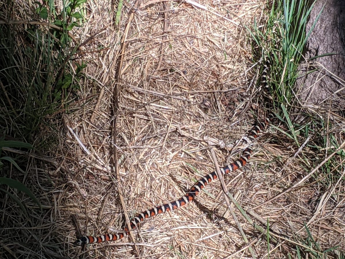
I saw more people than I had been. I passed a southbound hiker on a cliff overlooking a steep rapids. I tried to tell him about the cool snake I found but he wasn’t interested in chatting. (You can see a picture of the location below, but the guy took so long to start crossing I ran out of patience to get him in it.)
Although I slept in until nearly 7, it still didn’t feel like enough sleep somehow. I started packing in spite of the drowsiness and residual soreness. It was a cool morning with the smoke of the Black Fire hanging low over the campground.
I needed some water for my breakfast drink, and the lady who had checked me in was cleaning out the pools when I went over there. I asked how they cooled the spring water for the “cold” spigot and she explained it was a loop of thin pipe that went down into the earth and back up again, dumping excess heat into the ground. I had expected that would dump the heat into the river since it could move a lot more heat away with the flow. I figured the ground would equalize at a much higher temperature. And sure enough, the water marked “cold” was still slightly above lukewarm. But I was feeling very hungry and tolerated a slightly warm breakfast smoothie.
It was easier to pack up with a picnic table to arrange things on, even in spite of the chill air and my awkward stiff sore muscle motion. I had my pack ready to wear by 8:00 and started walking up the drive to the highway. Even with a break to read a historical sign, I made it to the Post before 8:30. When dumping my trash in the trash trailer, I met the lady coming in the back to open the store, and soon she informed me I could come in. She was studying the latest information on the fire, which was now only 7 miles from the area. She was annoyed at the lack of agreement and communication of the ranger district and other officials in charge of deciding how to handle the fire and whether to close the forest or which kinds of restrictions were in effect. She said I shouldn’t stick around too long or they would close the forest on me. But I had no intention of sticking around more than a couple of hours.
I bought a microwaveable breakfast burrito and a sandwich for later, both if which she had condiments for, two sodas, and some small supplies I had forgotten. I ate at the back picnic table and just as I was packing up to go, Lumberjack and Bucket rolled in, a day earlier than they had told the campground they would come and a day later than they told me. Despite getting there so early, they intended to stay the whole day and start hiking the next. But they didn’t want to hold me up and I started walking down the highway a few minutes later.
After being up so late, I think I did pretty well getting out of camp by 6:50.
The trail started with a bit of flat road walk, then climbed onto a ridge and just kind of mindlessly went up and down along that as the sun came out and the day got hotter.
I stopped for my morning snack just before what would be the longest steep climb of the day. It was a nice little moment of relaxation in the shade on a day that would not have much of it.
The climb turned out to be no big deal. Over in no time. Then there was a few miles of that same sort of mindless up and down walking along the side of the ridge. The trail randomly went straight up the hill for no apparent reason sometimes, only to immediately start heading down. Somewhere on a short climb out of a mini ravine, I passed a small snake curled up by the trail. It didn’t react to me at all. Maybe it was napping. I took a picture and went on.
About 11am, I reached the north trailhead for the section. I turned off the trail down a dirt road headed for a well that was to be the first usable source of water in some twenty miles. I ran out of water as I approached it, turning off the road and setting out overland directly for it.
It being nearly noon, the only shade near the water tank was a tiny sliver cast by the tank itself. I squeezed myself into it up against the cool metal and made lunch while my water filtered.
To return to the trail after lunch, I followed a cow track headed toward the tree-lined ridge to the west, where I assumed the trail would be. But when I glanced at the GPS finally, it said I had just passed the trail. I looked back and saw a wooden post standing there. The trail had set out across the prairie itself, with no shade to be found. Just a sequence of posts to follow. And those soon stopped appearing as well. They seemed to say “just go straightish until you run into that fence over there, ” so I did.
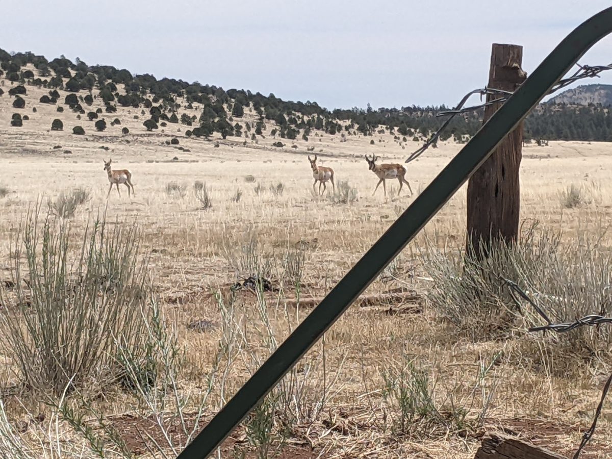
The next few miles were a CDT classic by now: walk along that barbed wire fence in a straight line no matter what the terrain does. Boring for the most part, except for the occasional antelope or rabbit sighting.
And then I came upon the fawn. It just lay next to the fence all curled up and didn’t react to me at all. Until I squirted some water on its body. Then it squeaked, scrambled under the fence and went running off at a good clip to who knows where. Maybe to find its mom. Maybe a shadier spot to rest. Either way, I hope it learned to fear humans who come near for the day when they are shooting lead instead of water. (After all, a deer that just stands next to you and lets you shoot it isn’t a very fun deer hunt, is it?)
By 3pm, I reached the highway, and by 3:30 I had made a sign. But no one was biting. In fact, they were signaling “no” before they were even close enough to read the sign. On the bright side, the cloud cover had increased somewhat, so I was boiling under the sun only half the time.
Finally a lady pulled off the side road behind me and invited me to go with. Only an hour and a half wait this time. And who was my first human contact in a week? Her name was Mesonika. It’s Polish. But she was diehard rural conservative, riding with a pistol in her lap, proud that her town had held a parade in the middle of the pandemic against the governor’s orders, referring to masks as “face diapers,” and insinuating I’m a crazy idiot for getting vaccinated. I changed the subject as soon as possible. Turns out Pie Town is named that after someone who sold pies to the folks coming through on cattle drives and the like long ago.
Anyway, she dropped me at Toaster House, which is a hiker box the size of a building. Almost all the food inside is free for the taking. There are beds. But most importantly, there’s a shower, which I availed myself of post haste, scrubbing away a week of accumulated dust.
Hawkeye greeted me at the door. He was holed up with GI issues, possibly Guardia. He said Banshee and Moving Average were there as well. The latter walked up just as he said that, and after a brief chat, I ran off to take over the bathroom for a while.
I spent the rest of the evening chatting with the guys, then standing in the street to get enough cell service to get some posts uploaded and handle other future business, and then grazing my way through the vast variety of free food, including soda, frozen pizza, hot pocket, pickles, an assortment of tea, canned yams, and I even baked a late night potato. I slept upstairs in the penthouse with Banshee, leaving my pack out on the porch because why not.
This day was not remotely a repeat of the previous.
Some things were similar. The weather, for example. The morning rapidly heated up once the sun rose, with clear skies until midday, when the storm clouds started gathering to provide shade and occasional sprinkles. In other words, pretty much the same weather as the last two days.
But the critical difference was that I did not experience sudden bout of narcolepsy halfway through the day. I can’t say that I changed much or the trail changed much, but I was full of energy the whole day through.
Well, actually the trail was a bit easier. The morning hike started before sunrise with brief climbs over a couple of small ridges separating me from the broad flats and floodplain. But as soon as I had completed that, and the sun was already enough to start beating down on anyone not in the shade, I took a sudden right off the nice meandering single track dirt trail onto a straight flat gravel road.
This was one of those places where there was basically no shade to be had, nor any interesting scenery. And it wasn’t even on trail. (Guthook thinks it is, but that’s another story entirely.) Why would I choose to do such a thing? Because the road led to Aragon Well, a giant well-fed tank for cattle, and one of the best water sources for miles. Also, a home for quite a flock of goldfish and one carp that looked to be an easy ten pounds. They eat the things that make tanks get gross, you see.
I took my morning break in the shade of the tank and walked out with a full bag of water. I didn’t really need that much for this stretch, but better safe than sorry.
Finding an underused and rockstrewn road nearby, I found my way back to the highway right where the trail crossed it. Where once there was a water cache and trail magic, I found a dozen empty water jugs and a lot of smashed soda cans. What a mess. Oh well, I didn’t need the water, obviously.
The next few miles were relatively flat, running between national forest land and ranch land, including the perennial barbed wire fences. This section was distinct, however, thanks to its unique metal gates in said fences, with laser cut metal CDT logos welded to them.
With little shade through here, the sun beating down, and knowing more water was available on trail, I began practicing the Colder Shoulder Technique, speaking each sleeve from shoulder to wrist with an entire mouthful of water. The relief was immediate, especially when the wind blew.
Since the sun was out in force, when it came time for lunch, I hid directly under a pair of trees just before the day’s longest climb. A relaxing stop in which I lay in the shade while a cool breeze blew across me. And by the time I was ready to go on, the clouds had started rolling in.
Frankly, the climb was much easier than the ones I’ve been doing the last few days. It was longer than some, but a lot more gentle. And a couple of clouds came over as I went to try to keep me cool.
The trees started to get thicker finally even as the trail leveled out and my pace picked up.
Soon I dropped into a canyon where there was an oak growing all crazy. A little way up the canyon was a boxed spring and I wanted to check it out, so I spent more than an hour in that canyon and came out with my water bag full again.
There was another nasty climb soon after this, short but very steep. But soon it was easy walking again, fast and shady.
In fact, it continued much like that for the rest of the afternoon. The clouds and trees providing sufficient shade. I felt good enough to go on for nearly three hours at a stretch before stopping for dinner.
And after dinner, after losing my way on game trails a couple of times, it was mostly downhill to the flats. There was nothing to slow me down then. It was a dirt road walk across flat ranch land. Where the trees had entirely burned away there were incredible views of buttes and conical peaks lit by the setting sun. The occasional elk crossed the plain and not a single beef in sight. (The several empty tire tanks said they were usually around through.)
Some time after sunset, I came to Rincon Well, another metal tank, which was reported to have good water. But it was just a muddy mire when I got there, with bats continually diving for moths and such close to the puddles.
I put on my headlamp and hiked up the hill. It was dark enough that I needed to stop soon. It had been more than three hours since I finished supper. As soon as I could find some level ground not dotted with enormous rocks, I pitched a tent and crawled inside.
Trail miles: 24.4
Distance to Highway 60 and Pie Town: 16.4 miles. Tomorrow!
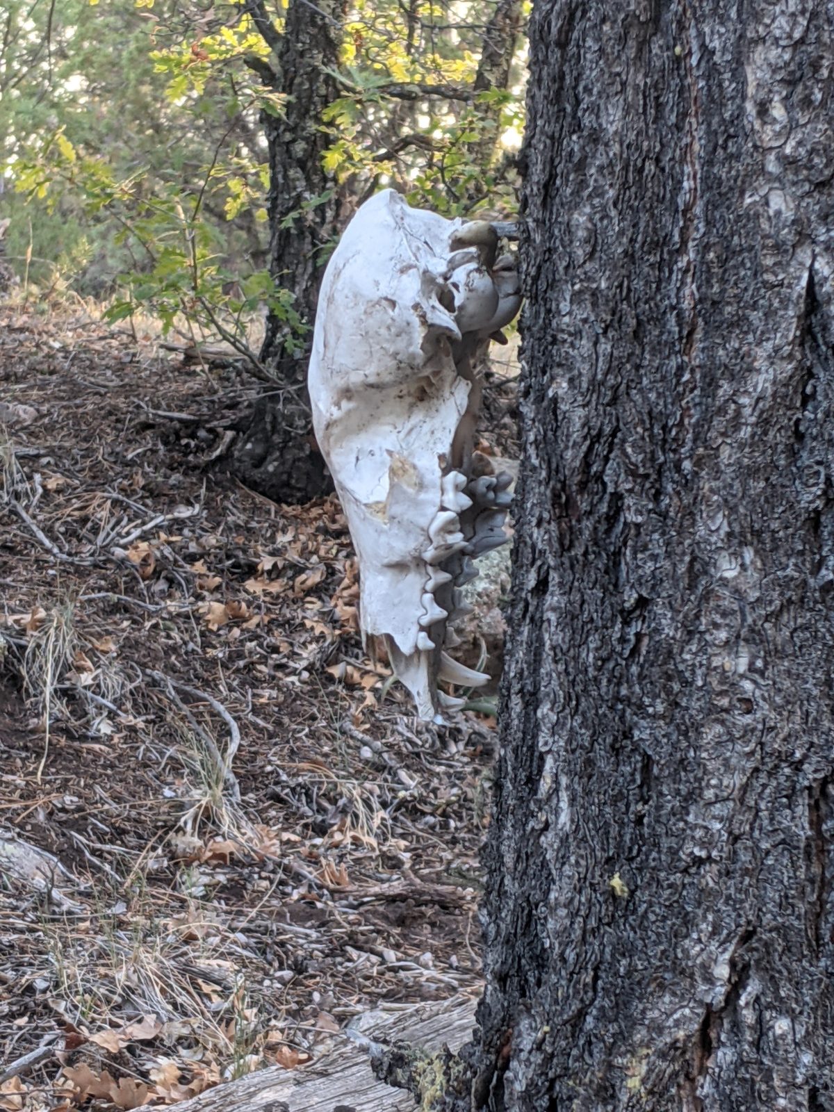
The skull of a predator judging by the canines, but what species?
I’ve come up with a rating system for trails based on my pace over them. It goes like this:
4+ miles per hour: Literally a walk in the park. (Example: Hat Rim on the PCT)
3-4 miles per hour: Easy Trail (Example: any of a number of mostly downhill road walks on the CDT)
2.5-3 miles per hour: Moderate Trail (Example: Most compacted clear footpaths that aren’t uphill)
2-2.5 miles per hour: Challenging Trail (Example: The harder bits of the PCT, uphill sections graded for horse)
1.5-2 miles per hour: Strenuous Trail (Example: Climbing Stone Mountain)
1-1.5 miles per hour: Bullshit Trail, and at the lower end of this range, Complete and Utter Bullshit Trail (Example: The 45 degree climbs strewn with rocks and fallen trees I’ve been dealing with the past two days)
Less than 1 mile per hour: What Trail? I Don’t Think There Was A Trail… (Example: The Mt. Hood Fiasco)
On this day, I was fortunate enough to be back on mainly moderate trail.
I left camp before sunrise this time, a bit worried about the water situation. I had maybe 20 oz left and put it all in my breakfast smoothie. I had 3.5 miles to go to the parking area, and from there it was a mile down to Dutchman Spring on the road. And the first bit of trail was a couple more of those ridiculous climbs I’ve been dealing with that easily earn the Bullshit rating. But on my Fresh Morning Legs (FML), I knocked them out fairly quickly.
At the top of the second and larger hill, blessed be, there was an actual footpath! And soon that became a full-on road! Downhill and basically free for 1.5 miles. It was here I spotted a group of elk below and could hear their calves squeaking loudly when they left.
Then it was another steep climb next to a barbed wire fence (of course), but at least there was somewhat of a track up it, and it was short if not mercifully so.
Anyway, I made it to the parking lot by 8, and yet another miracle occurred. There was a row of four 5 gallon boxes of water next to the fence. I made a morning drink to go with my morning snack and filled up everything and more to go. No mile round trip to the spring required! At least an hour of time savings! A great way to kick off a supravigintal day!
(I should mention that the title of this post refers to the fact that this parking lot is the north end of the Gila River Alternate. The next few miles from here are hiked by every CDT thru-hiker, though the confluence doesn’t last long.)
The sun was out and the trail was exposed ridges (more burned forest) for the next few miles. A couple of short climbs but nothing too bad. I took an early first lunch to celebrate my advanced schedule for the day in a flat area with trees dotting it irregularly. I picked one short enough that its shadow was unlikely to leave me and ate and laid in the shade, psyching myself up for the day’s first big climb coming up in less than two miles. I made my weird vitamin C drink to keep me pumped.
Approaching that climb, the clouds got a little thicker. One actually sprinkled on me for about a minute at noon. I went across the long flat section approaching the climb as quickly as possible begging a cloud to give me shade once it started. And the clouds obliged. Some of the worst parts of the climb were in the shade. Which isn’t to say it was anywhere near as difficult as the previous day’s climbs. There was an actual track and switchbacks for goodness sake! But carrying a pack full of water up 700 feet in less than a mile is never going to be easy.
So once at the top, I stopped at the first nice sitting log I could find and cooked one of my extra dinners for second lunch. I figured I’d restore all the energy lost on the climb. While it was cooking, I had to resist curling over on my pack and falling asleep sitting there. Even once I finished eating and started hiking, I didn’t feel my energy return. I still felt a bit sleepy.
I stopped again 4 miles later after a section full of views and shade and little challenge just to lie down and feel better, maybe power up with a dozen or so Starburst. The clouds had dissipated and there was little reliable shade at this point, nothing but tall pines. I found a semishaded spot and laid there for 3 minutes or so, until around 5pm. It only made me sleepier. But I packed up and pushed on, approaching my second big climb of the day like a sluggish narcoleptic zombie.
I decided to take this climb in the tortoise fashion. Drop into low gear with much longer slower strides and much fewer breaks. It worked out and got me to the top in about the same time as the hare method, not feeling too bad, though still sleepy.
On the north face coming down, it became clear why the trail designers thought it would be a good idea to run the trail over Wagontongue Mountain. It ran through a burned out exposed section with 180 degree panoramas of the entire countryside for a hundred miles. And the skies were filled with separate gray drooping rainclouds. One rained on me for a minute as I continued the descent.
A few minutes later, I came into a flat that seemed like the perfect place for dinner. I sat on a log and cooked dinner and an after dinner drink. In the past, this combination has given me a bunch of after dinner energy. Or perhaps it’s just the caffeine in the vanilla chai. I know it has nothing to do with the food by itself, since eating exactly the same sort of thing at second lunch had not picked me up at all. And anyway, not even the combination picked me up this evening. I still felt worn out, used up, broke down, flat busted, broke, and sleepy. But I still had an hour of daylight, so I went ahead and finished descending the mountain.
Very carefully. It was much further down than it had been up, and frequently quite steep. My knees let me know they were there. And so did the bleached skull of some small predator (fox? coyote?) that someone had hung from a tree.
But 45 minutes later, I was at the base and working my way across the flats on a twisted, rutted dirt road. I went as far as where the trail left the road. Someone had made a nice, wide flat campsite there, and it was time for sunset. I finished making camp by twilight. There would be no night hiking for me in this condition. I just needed sleep.
Trail miles: 20.5
40.7 miles to Highway 60 and Pie Town!
The skull of a predator judging by the canines, but what species?
Slow going again on this section. Not necessarily as draining, but definitely less interesting. And, for the most part, just as hard to get a good pace going.
As expected, I slept in a bit, which is to say, I stayed in my tent doing some maintenance and self-care tasks, as well as finishing a blog post it was too late to finish the night before. I didn’t leave camp until 7:30.
The first part was a breeze. Up to the shoulder of the mountain and down the ridge on what amounted to an actual footpath, if a bit overgrown. At the bottom, the trail soon joined a brand new perfectly cleared and compacted section through a bit of forest. After a mile, the forest continued on about the same while the trail switched to a more overgrown and easier to lose state. I took my morning break behind a nice rock formation.
As far as elevation goes, it was pretty gentle rollers all morning. Climb over a ridge, come down the other side, etc. The trail came down to an open area with a fence across it. Where there once would have been a gate someone had replaced it with a section of wired in barbed wire fence. And if that wasn’t rude enough, the bottom wire of the whole fence was not barbed except in that section, where they knew hikers would be having to crawl under it. I bent the separator wires to give as much crawlspace as possible for me and the next person, but I would have liked to have just removed the wire altogether so whoever was responsible would learn that that sort of thing was unacceptable. Put the gate back!
Just after a road crossing, I had a gut feeling it was time to stop. I had lunch there and by the time I left a bit over an hour later, some heavy clouds were rolling in. They would, throughout the rest of the day, go from partly cloudy to completely overcast. At this particular moment, they intermittently gave me long periods of shade.
Just a bit after lunch, I went through a tension gate and crossed the floodplain of East La Jolla Canyon. There was a sign saying the area ahead was full of obstacles due to a fire. It wasn’t lying.
On the first ridge, I kept losing the trail. In places it was marked only with yellow ribbons, possibly because I was on a future reroute. Other times, I was following cow tracks around the side of the ridge when the trail was way above me. But with all the downed trees, the cows seemed to have the better sense of it. Eventually, I climbed up to a nice section of brand new trail, clean and clear of the ankle breaker rocks. It lasted all of ten minutes, dead ending into a series of fallen plastic and wire flags showing where it would continue. Straight up another hill, that’s where. I crawled under a tree near the top and had a second lunch as my afternoon snack.
I came up to the shoulder of Pinon Knob and the descent there was through a light jungle gym of fallen trees, some with CDT markers still attached. It was not as long or as dense as the Mt. Hood fiasco, thank goodness. At the bottom of that began the day’s first serious climb. It was just like the day before, 45 degrees straight up, grass and chunks of rock, occasional markers and cairns. But this time the challenge was increased by the way being constantly blocked by fallen trees. Up 500 feet I went in a half a mile.
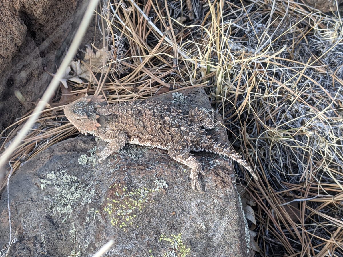
My first animal encounter highlight of the day happened on this climb. An enormous Horned Toad Lizard, much bigger than I am used to seeing, got scared off my path. I ran it around a bit to get a good look at it.
The burned forest continued. No footpath in sight, but even if there were it would have been crossed by fallen trees. This section was a nightmare to navigate by sight. For the most part, though, it was predictable. It tried to stay on top of the ridge the whole way.
And there were markers enough. Three kinds: cairns, tree cuts, and plastic CDT logos. The next marker visible from the last could be any of the three, and usually only one marker could be seen if any at all. If it was a cairn, it was probably too short to be seen over a rise or a snag until I came closer. And there were plenty of natural rock formations that resembled cairns from a distance. If it was the CDT logo, it might be so melted in the fire that it has shrunk down to near invisibility. If it was a tree cut, the cut and the surrounding bark might both be burnt black, but it was probably cut in a tree where the underlying wood was the same color as the bark anyway. Either way, I had to scan both the ground and the trees for the next marker each time, something easy to forget to do.
And there was a good heuristic for spotting the next marker: look straight up the hill, straight down the hill, or toward the center of the ridgeline. Head in that direction until you see one. I got so used to this tactic working that I lost the trail doing it.
I came upon a bull in the trail and had to bully him and evict him from my path several times in a row to keep going. Then I looked at my GPS and saw that I was walking down the wrong ridge and had been keeping him running for no reason. Sorry!
Back to the trail and over the next ridge, I found a good log to sit on for dinner. It wasn’t under a tree like usual because the cloud cover was so final that everywhere was shady. It took an hour or so to cook and eat and so a number of other chores, even though I hadn’t even been hungry yet. But I knew that I could hike faster if I ate something substantial.
And I did. The trail did not change by much. Somewhat fewer fallen trees. But I did hike faster up the hills and over the rolly rocks. I kept going past sunset until it was just about too dim to be able to make out the next marker and stopped in a saddle. The first piece of ground I came to was perfect, but was right next to a tree leaning on some other trees and groaning loudly whenever the wind blew. I moved just far enough away that that wouldn’t be so loud to keep me up all night and made camp. Asleep shortly after ten.
Trail miles: 18
The only way through is under
This bright yellow lichen caught my eye
It’s like the trees died trying to bend themselves into a round hut of some sort.