It was a pretty standard morning. I woke up at 5 to finish writing blog post and slowly got myself going. It wasn’t too cold, but my tent was damp and holding onto more dirt than usual. I got started walking around 7 and had made it to Gully Spring within fifteen minutes.
I didn’t stay long enough to filter the water I collected. I just threw the full reservoir on top of my pack and kept hiking. I stopped again a little after 9 when I had made it down into the Disappearing Creek ravine. It was shady and cool and there was a nice sitting rock and trees to hang my gravity filtration system from. So I sat for 30 minutes or so before continuing down the ravine and then out onto the ridge again and into the hot sun. It was 3 miles before I reached at 11am the point where I knew I would have cell service, and reported to mom that I was 3-4 hours (7 miles) from the highway.
Much of the trail through the Castle Crags Wilderness and Castle Crags State Park was in direct sun, with only occasional short sections in shade and trees, and the temperature was already in the 90s by this point, so I took advantage of every bit of shade and coolness I could find.
That’s why when I reached West Fork Sulphur Creek, I took a break to lie down on the bank with my head in the cold water and soaked my shirt through. The pool was shared by the first salamander I had seen in the California wilderness, though I have heard they are all around this section.
I saw another salamander deep in a bathtub sized pool in Dump Creek a few miles further on where I soaked my shirt again. There were other little streams along the way but sometimes I just opted to keep moving.
In fact, I didn’t take any more snack breaks until I reached the road at 3pm. There was shade there but basically no cool air. The sun cooked up from the pavement below. The concrete barriers were too hot to sit, so I sat on my pack for half an hour waiting on Mama to arrive in who knew what kind of vehicle. Turns out she was stuck in construction traffic in a trail-ready Jeep Compass.
Anyway, she met me with an ice-cold root beer, took the obligatory picture, and then drove us half an hour through Weed to a country club where we checked into a condo. I got cleaned up and changed clothes before we left to visit the Mt. Shasta Brewing Co. in Weed.
This was a great choice. They had some interesting brews and the spinach artichoke cheesy bread was too die for. Plus the stories about the brewery itself and the town were incredible. Apparently, Weed was voted the funniest town in America, Netflix bought everyone in town dinner, and Ziggy Marley helped the brewery sue the federal government for destruction of $20000 in product plus lost wages and suffering.
After I had sampled as much as I wanted, we hit up the dollar general for laundry detergent and ice cream, drove down to see what once had been a sizeable lake but was now a grassland with a few puddles of water, and finally went back to the condo. I spent all evening lying around watching videos online while my clothes were washing. I also ate a ton of ice cream and drank a ton of root beer. Why not?
I didn’t get to sleep until 2am, but that just meant less sleep for the road trip to follow.
Trail miles: 15.5
Number of unfinished (closed) PCT miles to clean up some other year: 115.1
I actually woke before the 5am alarm. The birds were already raising a ruckus well before sunrise. I tried to go back to sleep, but then the alarm was going off. I opened my eyes, turned on my phone, and finished the previous night’s blog post. Then I got out my needle and thread and sewed up a gash in my sleeping bag I’d pulled open the night before trying to free the zipper (poor design, Kelty!) before the down could all spill out.
I was packed enough to leave the tent shortly after the 6am alarm and I finally got a good look at the lake I had camped above just as the sun was touching the top of the opposite ridge. It was somewhat anticlimactic actually. I’ve seen more picturesque lakes. Upper Deadfall Lake reminds me most of Blue Lake up in WA: big, open, unscenic, utterly enveloped by people in tents. (On my way out later, I went out of my way to walk up to it from a different side, and it was even less interesting from that angle. Not even worth a picture.)
The couple from the night before was still asleep in their tent on the other side of the campsite. The man was loudly snoring away. So I packed up as quietly as I could. I also had to pointedly avert my eyes from the girl who was digging a cat hole in a spot in clear view from my campsite. She saw that I saw her, comprehended the situation, and looked away, so I tried to keep a tree trunk between us until I thought she must be done. I’m sure she was desperate or she would have gone further up the hill away from the lake and all the other campers.
Anyway, I was back down the hill to the trail by 7, and I got to do the first few miles in the shade of a ridge. When I was about to go through the pass to the other side of the ridge, I stopped to put on sunscreen. (I also downloaded some more music and a podcast to hike to because there was good cell service at the pass.)
And after that, it was all sun all day. The sections with lots of trees were short and far between. There were a lot of sections with a few sparse trees casting short, single shadows, but lots of sun in between. And it was also a hotter day in general than the previous two.
I took my first break a quarter mile uphill from the trail at Porcupine Lake. This one was a lot more scenic and smaller, but it was still popular. The last guests had left a ton of trash, packages full of uneaten food. I packed out what I could in my own trash. I also collected water from the lake, and had my usual morning snack and vitamin drink.
My next stop was at around noon. I had passed up stopping at White Ridge Spring because I had plenty of water and there were already people gathered there, but this meant I had to stop at the road crossing where lay the trail to Picayune Spring. I had my break first to energize for the climb down to and back up from the spring. It was a great little spring, but the trail was 370 steep yards down and up.
After I got back to where I had left my pack in a little roadside campsite with some shade and started filtering water, I felt a headache coming on. I don’t know if it was the heat, the lack of sleep (darn birds), or just sitting too long after I had been walking hard because I basically don’t get headaches. But I figured I had a cure. I took a naproxen and a Stacker 2 B-12 supplement I had acquired for just such a circumstance. No headache could possibly stand up to the one-two punch of Aleve and 150mg of caffeine. That’s like two times more potent than Midol, right? And it did, in fact, work. The headache was pretty much gone within the next mile of walking.
Since I had taken such a long stop at the spring, it was lunch time a little more than an hour later. I usually hike more than an hour at a stretch, but lunch is one of those things you just don’t want to put off for two long. There was a rock in the shade and I just knew it was time.
A lady passed me just before I was ready to start packing up to walk again, and I used that lunch energy to catch up to her within a few minutes of starting hiking again. She was looking for Helen Lake. I told her the side trail to it was still ahead and then I beat her to it by many minutes.
Here I was climbing in the sun, but I had turned on a podcast upon leaving lunch and could basically turn that distraction into an ability to climb the long uphill section I was on without noticing the heat or the exertion.
I took my afternoon snack break at the top of the climb, the highest spot I would reach that day and the next day too. I was pooped, temporarily, even though it hadn’t really been that steep. I also noticed there was cell service at this point too, and wasted a few more minutes here just trying to download one more podcast that just wouldn’t come fast enough. I gave up and kept walking down into the Castle Crags Wilderness.
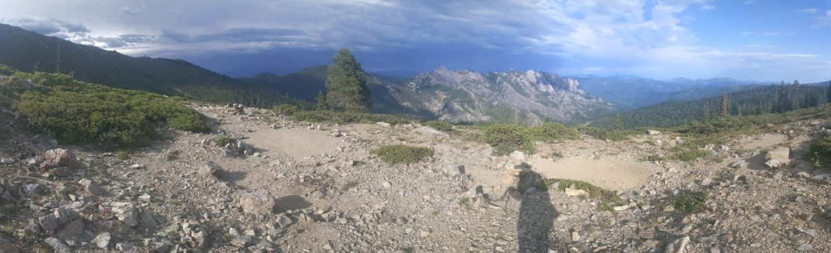
Soon I found myself on a cleared promontory overlooking the entire valley between me and Castle Crags. I saw Mount Shasta behind them, lurking stealthily under a dark raincloud. You might not think a 14000 foot peak that towers over the landscape visible more than 100 miles in every direction can hide, but it really was doing an admirable job of blending in with the dark sky.
It sure looked like that cloud was headed my way. Just a little way beyond this, I met Presto heading north. We were both eager to continue north, and we shared what details we knew about the trail ahead (and the town of Etna in my case). The cloud did come up, especially in relation to how it wasn’t supposed to rain that day. Then we both hurried. I passed two more thru hikers who had just left Dunsmuir that afternoon but did not get their names.
Then it was 7 and time for supper. I dropped down into the next tentsite I passed. It had a nice sitting rock to cook from. Another hiker passed and asked if I thought it would rain. I said I thought it was about to start raining, but it would only rain a few minutes and blow away.
It did start raining pretty good while I was waiting on my food to cook. I got my coat on and covered my pack, but then I started doubting my prediction. I could see no end to the cloudbank. What if there was another storm coming in right behind this one? I knew that I didn’t really need to go any farther that day, so I just decided to go on and pitch my tent. It was a really cute tentsite after all, and I had plenty of water to hand.
I was in my tent before 8 that evening, the earliest, I think, I’ve encamped this year to date. I did all my set up from inside because it was still sprinkling out. I even cooked my after dinner drink from within.
My prediction turned out right, of course. It didn’t rain hard again after dinner. It even stopped sprinkling by 8:30. I could very well have hiked on after dinner. But why bother? I could get a nice full night’s sleep for once.
Trail miles: 20.6
Distance to I-5: 15.1 miles
the orange tent is the couple I talked to last night
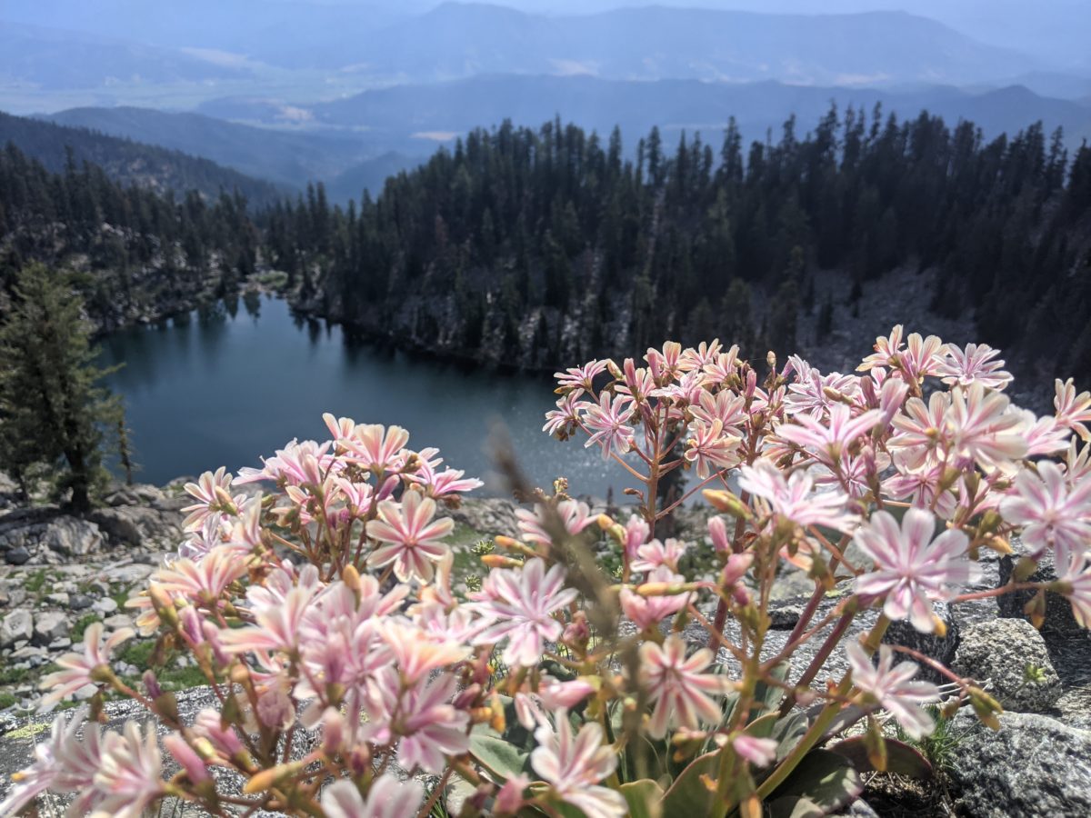
upper Deadfall Lake
Porcupine Lake
Picayune Spring
believe it or not, Mt. Shasta is the tallest mountain in this image. can you see it?
The trail through this section just keeps getting easier. This day, aside from a short climb right at the beginning, featured nothing but trail that was either mostly level, or sloped so gently as to make no nevermind.
I woke up in a huge campsite that looked like it was cleared for parties of 20 or full size RVs. Except how there was only one picnic table. Although I woke up before six, I decided to try to go back to sleep until my 6am alarm seeing as how I needed all seven hours of sleep for a full hiking day. But soon enough I was taking full advantage of that picnic to speed my packing up.
There were campers in all the more reasonably sized sites all around me, some of them awake and packing. I asked the man loading up across from me if he knew where a trash can was if there was one. I say “asked” but I was really yelling in an otherwise quiet morning campground as he was very hard of hearing. He didn’t know. He wanted to tell me all about himself, so I asked if he knew where the privy was. Sometimes there are trash cans near or in privies. He didn’t even know the campground had one. I excused myself and went to find it. No trash can. I would have to pack out my trash when I left. No problem.
I noticed there was a proposal to attach a 15 dollar fee for camping at the campground (which was currently free). I’m all for it if they use the funds to add trash service to the campground and waive the fee for long distance hikers who probably won’t have the cash on hand to pay it and would opt to climb out and put greater pressure on potential tentsites on the nearby hillsides.
Crossing the road, I was accosted by Pony who claimed to have met me in the Sierras this year. Nope, bud, you’ve definitely got the wrong guy. But he just wanted directions to the toilet. A loud, brash, unafraid man who had no time to chat. Well, if you’re desperately seeking a toilet, that stands to reason.
After a brief mile or so of climbing, I came around a corner and met a woman with a dog tucked down her shirt asking if I had just passed a water source.
“No, I think you just did.”
“Well, yeah, but the comments said there was a better flow 100 feet north.”
“The one you just passed probably is the one 100 feet north.”
“I just didn’t want to have to go backwards.”
She took the dog out of her shirt and her pack off a moment later, and I realized we were at the good spring. Exactly where I wanted to take my morning break because I needed the water too.
Her name was Kangaroo (because of the dog in the shirt obviously–just picture it) and she was a pretty fast hiker. She was from New York and did the Long Trail with the dog in 2020. And now she was on Day 69 of her purist northbound PCT thru-hike-with-dog. Calculating it out, she was averaging nearly 23 miles a day with town visits and zeroes factored in. Which meant she was doing 27 to 28 miles most days and frequently in the 30s. Fast, like I said. She was so fast she got ahead of her bubble and did hundreds of miles in the space between bubbles before catching her current tramily, who hiked faster than most but she still had to slow down to stay with them–or else get lonely with no humans to talk to again.
Soon after she left, the other members of her tramily started showing up. None of them had to stop for water, so I didn’t really meet them, but we spoke. I met another couple (individually) a little south of there who had camped with them the night before but had no intention of trying to keep up with them.
I took another break a couple of miles up on a random rock that happened to be in the shade. Then one more break a mile or two later that I hadn’t planned on, but there was good cell service and I just felt like it. Then a huge family group with small crying children appeared out of nowhere, and I ran up the trail. After a mile or two, I found a shady enough sitting rock to throw myself down for lunch. I did lunch as quickly as I could and hiked on.
With one unscheduled stop along the way, I pushed on as fast as I could to a Chilcoot Creek for another break. I had originally wanted to collect some more water there, but I met Pathfinder and Cruise (as in cruise control because she only had one speed) who told me this water was not convenient to collect, but the stream in 3 miles was. Pathfinder also wanted to know about the water situation ahead.
Even though it was only 4pm, they indicated they were only going to go a mile or two more, probably just to Bull Lake (which I had just passed). In fact, they were in the middle of cooking supper. Pasta Sides with bacon bits and grated Parmesan cheese. They always packed bacon bits and Parmesan and put it on whatever they ate.
“Wow, you guys are rich… rich in flavor.”
And it seemed to work for them because they had already done the whole PCT and were working through it a second time by sections. This despite being to be horizontal by 7pm each night–when I was usually eating dinner myself. They call people who hike until sunset like me late night hikers. That’s what they said when I told them I meant to go 9 more miles to Deadfall Lakes that evening.
They packed up and hiked on, and with an immediate goal of that better water source just a few miles ahead, I put on my headphones, put on some music, and hiked as hard and as fast as I ever have over rocky but basically level trail. It took less than an hour.
I didn’t waste any time at the streams for a full break. It was going to be supper time soon anyway. I just grabbed the water, filtered it, and left. (While waiting for it to filter, I was singing along to Bolero at the top of my lungs when another hiker appeared and stopped to collect water. I stopped singing, but I refuse to be embarrassed.
I set out again at full speed… which was maybe not quite as fast as when I had the music and that snack energy. I hiked until I could see a potential spot for supper: a place where the ridge above the trail came down to a saddle that was only a bit above the trail and I could climb up to it easily. I was able to find a relatively flat spot in the shadow of a trail tree up there. I also could see a town in the distant valley, which meant cell service. I used that to grab a few more podcasts, then started cooking.
It turned out to be a very windy spot. I had to set up a wind barrier with my hat and bear can to stop my stove from blowing out. I also had to put on my down puff. But despite that, I was able to get through supper very quickly. Somewhat less than the usual hour. I had gone up just before 7 and was back down to the trail about 8.
I had a bit under 4 miles to go to get to Deadfall Lakes, and it was basically level and slightly uphill. So I put on a podcast and pushed myself as fast as I could. I passed the Parks Creek Trailhead a few minutes later and saw a ton of cars. I had been told by the hiker I had seen at the last water source that there had been a good number of visitors to the lake, some set up to stay. I was expecting a hard fight for a tentsite.
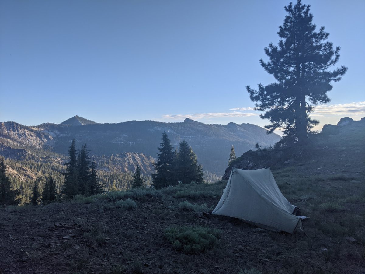
I came into the Deadfall Lakes area around 9:20, the sun a thin glow on the horizon. I started working my way from the trail along the lake shore and up the adjacent hill. There were tents everywhere I looked, tucked into even spots that didn’t seem particularly comfortable. Eventually I came to a clearing overlooking the lake with an older couple standing in the dark waiting to the see the moon rise over the ridge. They were the owners of the tent and were happy to let me camp on the other side of the clearing (which was quite large).
While chatting with them about the area and their day and the weather and everything else innocuous, I set up my tent by headlamp right in front of them. The moon rose and I crawled inside mine just after they returned to theirs about 10pm. Always nice to find a pair of friendly fellow night owls.
But unlike me, they were not also early birds. The wouldn’t be getting up until I was already up and packing. But for that to work, I would need some good sleep, which wasn’t easy given the clear view of the clear sky and the bright full moon. I woke up at midnight, just an hour after starting to fall asleep, thanks to my eyes understanding that powerful glow outside my tent as daylight. But eventually, I did manage to get in a few good hours of sleep.
Getting a good night’s sleep worked a trick. That and the trail getting easier.
I woke up at 5 and stayed awake. When I emerged from my tent, I found I had invaded the home territory of a critter that seemed hardly bothered by me at all. And my stuff didn’t seem to have been bothered either, so we were totally cool with each other, I guess.
I was back on trail by 7, and by 9 I had covered the 3.5 miles downhill to the greatly flowing South Fork Scott River. Although the sun was out in force, there was still plenty of shade near this stream. Not only did I collect some of this water during my morning snack, I also dunked my head in the water until I had lost all excess heat and soaked my shirt and Buff (around my neck) before I left. I had my biggest climb of the day ahead, much of it directly in the sun, and I wanted to be on the brink of shivering cold before I started for extra speed.
It worked a treat for a few minutes. I was really moving. But within a mile, the water had warmed up and evaporated, and I was slowing down. Luckily, right about then, I crossed another stream, soaked my shirt sleeves again, and that cooled me enough to get me to the top of the climb.
I took a second morning break–let’s call it elevensies since it was just after 11–at a pair of nice streams on the other side of the ridge just 3.6 trail miles from my first morning break, and collected another bag of water, enough to get me to and through lunch. There was intermittent shade, enough that I felt no need to soak my shirt again, plus the trail was not going to be steep again for a while. Just rolling slowly up and down along the side of the ridge, then into a flattish area with meadows and a lot of water, then finally onto a saddle where I took lunch under a tree practically in the middle of a side trail.
I stayed on the ground chasing the shade for more than a half hour after I had finished eating. I was very relaxed and I had cell service, so I downloaded a video to watch over dinner.
Less than a mile after leaving that spot, I ran into a PCT thru-hiker, Terminator. He was trying to do an ultralight hike in 100 days with only four zeroes. If you divide that out, it’s over 27 miles a day on average, which means he puts down 30s and 35s on a regular basis. That wouldn’t even be possible without a UL system.
The next section was very nice. No more meadows, just rock slides. Piles of red rocks and views for miles. Mt. Shasta, as always, imposed itself over everything else in view.
I stopped for an afternoon snack right at the beginning of this rocky section, just after leaving Terminator, on a nice rock that happened to sit squarely in the shadow of a tree. I was a short break, eating and drinking just enough to stop the sinking feeling in my gut long enough to get me to my next stop.
Which was 4 miles all downhill–so under 2 hours of walking–to the outlet stream of Mosquito Lake. I couldn’t see the lake itself, but the stream draining it was gushing. I made the most of this stop, eating dinner, collecting water, consolidating trash, and watching the video I had downloaded, all in an hour.
Since I had finished supper at 7, I had a solid 2 hours of daylight remaining and even more twilight than that. The trail was all downhill and mostly clear, and once I was maintaining a 3mph pace, I decided I might as well go the full 6 miles to the campground at Hwy 3. I would make it just after 9, which would mean a teensy bit of twilight to madness camp by.
On the way down the last hill, only a mile out, I met Tenderfoot who was just about to finish a 40+ mile day, beating his record by more than 12 miles. I convinced him to skip Etna, since with the food he had and the pace he could keep, he could easily make it to Seiad Valley before anything ran out. Then we parted ways.
Soon, I had arrived at the campground where I would stop. It was 9:20 and pretty dark, so I worked by headlamp. There were other campers around, but they were quiet, and there was plenty of space for me. I set up in a huge cleared campsite. The ground was so hard, I bent my biggest, toughest stand trying to drive it in. Then I straightened using the links in the chain that held the picnic table in place and drove it again. The other stakes were also a struggle. It was well after 10 by the time I just had the tent up, much less my bedding down.
I wasn’t ready to sleep until after eleven. So much for trying to hike reasonable hours. At least this time I had the miles to show for it.
I got up by my 6am alarm and started packing immediately, filling my water bag at a nearby spigot while doing so. I was ready to leave the park by 6:40. I walked into town looking for a power outlet for my phone to get a little bit of charge while I waited for the Wildwood Cafe to open.
Luckily, when I showed up at the cafe, they opened ten minutes early for me, so I got to plug in right away and order right away. Five minutes later I had a latte. Ten minutes later I had a loaded breakfast burrito (a hard decision–this cafe had every breakfast item you could dream of: breakfast biscuits, croissant sandwiches, pocket omelets, avocado toast, yogurt parfaits, oats with fruit, and every pastry you can imagine). No sooner had the burrito arrived than I was ordering a peach mango smoothie.
Shortly after I had received the latter and eaten the former, I got a call from Sole Saver (Shannon), who was already ready to go five minutes earlier than requested. She had her mom’s car, a puppy, and another hiker who had claimed the front seat and would be starting 20 miles south of me headed north.
I didn’t get many chances to add to the conversation between the other two. They talked pretty much the whole way up to Etna Summit to drop me off. I get the sense they had a lot in common, such as being part of military families. I know nothing about what that’s like, so I mostly just listened.
I was dropped off just before 8am and by the time I got my sunscreen on and hiked out, it was that time. I had to start with a 3 mile climb up from the pass. You never get on trail from town without a long uphill section. Fortunately, even though the sun was already out in full force, the trail stayed on the shady side of the ridge. Even when it briefly switched sides near the end of that long climb, there were enough trees to give me some shade.
I also had to get over a number of snowbanks at that point, large and small. The biggest one, I climbed over and around by kicking little steps into the slope. And of course, to beat the heat, I kept taking handfuls of snow and putting them on the back of my neck under my Buff, which held it all there until it melted (which took somewhat longer than you might guess but not nearly long enough). All in all, the high point of that initial climb was also the high point of the day in terms of scenery, looking down on a lake that itself sat way above the valley below with all the people and their tiny ant-sized buildings in it.
I took a morning snack break on a shady rock just before I reached the outlet of Payne’s Lake, where the water was not near as cold as I would have wanted as I spread the water all over my shirt. I missed the snow already. Then I got to immediately climb another two mile hill.
I was back on the other side of the ridge for the rest of the day, and as midday came and went, so also was the sun. Luckily, clouds had gathered by this time, and there was a several hour period where the sun spent more time behind clouds than beating down on me.
I climbed up to Statue Creek by 2pm, which I deemed lunchtime. I ate sitting on a low rock between two trickling streams. This was clearly the headwaters of the creek in question because no one would call a stream that small a creek by itself. I was disappointed that the first lime from the batch I bought in Etna was bad and already tasted like furniture polish or floor cleaner. I ate it anyway for the vitamins.
As much as I wanted to not be hiking, I had to go on. I dropped elevation very quickly coming out onto the side of the long uninterrupted ridge on which I would spend the rest of the day. For a couple of hours, I crossed several streams per mile. Most were small and cute, but my aim was the last one for the day, a place for another snack break and water collection. It ran under a rock slide over which the trail was built, then popped out just below the trail, where there was a nice rock to sit on and catch it as it fell from the edge of a small pool. There was a bit of shade nearby too, but no place to sit off trail. I ended up sitting with all my stuff in the middle of the trail, but no one else came along to be bothered by it.
My next destination was a dirt road just after an unreliable spring. This meant another two mile steep climb and then a short descent. The spring was actually flowing well, right over the road and down a chipmunk hole drain. I followed the road to a saddle and threw down my Tyvek right in the middle of it. I had dinner sitting on the ground on this rarely used forest service road. There were tons of mosquitos and other bugs, but I had my DEET and headnet.
I didn’t want to quit while there was still light, but I didn’t want to hike after dark either. I rejoined the trail and went another two miles before entering a dark and spooky pine grove nestled in a crook in the ridge. Here I left the trail and climbed straight up the a saddle in the ridge. There were no marked tentsites here, but I got lucky. The saddle was a small clearing, a meadow of sorts. There were more mosquitos than I’d yet seen here, but it was nearly dark, so I set up amongst them.
I was in bed before 10, and going to sleep by 10:30. I was awoken by brief rain showers at 11 and again at midnight, but they were brief and light and did not recur, so there was plenty of sleep to follow to make up for the lack thereof the night before.
Trail miles: 17.0
Distance to I-5: 82.3 miles
snow bank on the trail on one of the hottest days of the year