I got up at 6:10, showered one last time, made breakfast and coffee in the room, dressed for hiking, and headed to the office before 8am. I chatted with Julio’s wife (Sandra?) about the town and the work of operating such a property while waiting for him to arrive. When he did, he made some coffee himself, then we loaded into his Jeep and set off up to the pass. On the way, we chatted about fires and floods, bureaucrats and babies, trailers, trains, and tourism. We climbed through a verdant but clouded landscape, occasionally slowing for cows in the road, until he dropped me at the trailhead at 8am. He refused any gas money for going so far out of his way saying it was just a service they offered.
As you might expect when starting from a mountain pass, the first part of the trail was a rapid climb on a series of switchbacks, but I obtained the ridgetop quickly, where a short spur granted access to the top of a tall rocky prominence with views of the entire valley below and mountain range above. The trail was as wet as could be and my socks were instantly damp. The muddy trail was occasionally deep enough to sink into or slide across but was mostly in good condition. The wildflowers were loving the monsoon season though. The unusually late rains were making up for lost time and the grasses were taking full advantage. Julio mentioned having to mow twice a week, but up here it just meant color everywhere.
Coming along the ridge a few minutes later, I popped up over a rise to see a small herd of elk in the field below, and they immediately saw me as well. They started to leave hastily, but not so quickly I wasn’t able to snap a few quick photos.
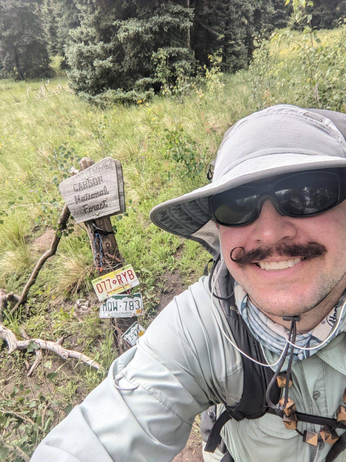
Just past that point, I arrived at the Colorado/New Mexico border, my last border of the CDT. I may have said I finished the Colorado part of the trail last month, but I lied. I still had these two miles. In other words, within a week (by half a day), I finished up three states on two different trails. One more state to go on the CDT.
At 10:30, I stopped for a break on a big rock, and by the time I was ready to leave again, I could hear the whistle of the Cumbres & Toltec coming up the valley below. It was on the other side of the hill where I couldn’t see, but it was absolutely operating.
The trail went the other direction though, across a creek or two and into the woods where I found more plump, ripe strawberries, though they weren’t as sweet as some of the ones up north. The trail here was extra wet and muddy, frequently crossed by streams. It climbed until it joined a road just below another ridge, a road immediately crossed by several huge deadfalls. I was feeling pretty peckish by now, but I climbed the hill to circumvent the mess and escape the cloud climbing over the hill before seeking a spot to sit for lunch.
I propped a large rock on a log for a seat, scratched my knees furiously from all the trail grass I was walking through that my immune system wasn’t fond of, and set to making wraps. While I ate, I had a few brief moments of direct hot sunlight before the clouds returned. No serious rain yet, but it seemed sure to arrive later.
On the bit of overgrown road following that, there was occasionally so much water and tall grass it was indistinguishable from a meadow. But between those sections grew some of the biggest reddest strawberries I’ve seen this year, and some of them were actually quite sweet. Strawberries kept showing up in the trail mile after mile, and I occasionally tried them, but they were often so disappointingly bland I eventually stopped.
Throughout this section, the sky got clearer and the moments of bright sunlight got more frequent. There were still fat clouds across the sky, but there were rivulets of blue between them–it was no longer a solid mass.
Soon, I arrived at the highest point in this section, and indeed, the highest point on the CDT in New Mexico. It wasn’t a mountain top. It wasn’t even a hilltop. It was just a spot where I turned off a road that was climbing and started descending into the woods on a single-track. It was, on average, all downhill from here.
Just before 3pm, the trail came out of the woods and opened up into a grassy field with a few stands of trees dotted here and there. I stopped for a snack under such a cluster where it was clear cows often also hid from the sun. Looking ahead, I still had some decent number of miles to put in, so 25 minutes later, I rolled on.
Out in the meadow, the trail crosses and comes alongside a grassy creek so overflowing with water it was coming up into the adjacent trail in places. On the other side of the meadow, a herd of cows decided to take the trail up the hill in front of me, and I had to stop and let the stragglers cut in so they could catch up with the herd. Their tracks and the trail coincided for so long that I didn’t see the trail turn off. A half mile later, I stopped to get out my Packa because the rain had started, and on restarting, noticed I was off trail. By heading backwards at an angle, I met the trail only a quarter mile away. And, by then, the rain had stopped.
The trail wound crazily through open grass crisscrossed by cow trails, and infrequency of markers yielded a lot more opportunities to lose the trail. But now I was on notice, constantly checking the GPS and finding the trail again before I got more than a hundred feet from it. There were all kinds of switchbacks going down a hill that wasn’t steep enough to warrant them. A trail straight down the hill would have worked just fine and there was plenty of open grass to put it in. You can believe I shortcut some of them. On the other side of the road I crossed at the bottom of the hill, more switchbacks climbed another hill, and again they weren’t steep enough. But it didn’t take long to reach the hilltop where my empty stomach bade I find a place to make supper. I set a flat rock on a rotting tree trunk and called it a chair then started cooking.
All day, after the coffee with breakfast, I had only drunk a single liter of water, slowly. The clouds had kept me too cool to sweat, and even by supper time, I still was overhydrated. Water, water everywhere, but never a need to drink.
Speaking of water, although skies were partly cloudy with storms on the horizon over dinner, it wasn’t but a mile or so (during which I saw more elk) before the rain started. I stopped and put my Packa on as soon as even the lightest rain started, and it quickly picked up. My Packa isn’t really waterproof anymore, so while, with the help of my ground cloth, I can keep some portion of my pack dry, I will still get wet down my back and sleeves. It keeps in enough heat to warm the water that gets in at the speed it gets in, so I don’t get too cold. But I was basically as soaked as I was headed into Lake City a month back.
The rain let off a bit as I started climbing Brazos Ridge, but now there was lightning not too far away, bright enough to surprise and loud enough to be heard over the music I was pumping. I put on a two hour playlist with a plan to stop hiking when it ended.
The rain had mostly dissipated by the time I reached the high point of the ridge well after sunset. Yeah, I was definitely missing the long days I had in Montana. I could easily see the trail in the dark despite the clouds, even when it started doing funny switchbacks again. It was mostly open, not dense forest, so the diffuse light came through.
When the playlist ended, it was too dark to be able to judge the ground for camping. It seemed to be very rocky terrain, but there were pockets of dirt or smaller rocks between stretches of large ones. I had to stop, take off everything, get out my headlamp, and put everything back on before continuing until the area looked more camping-friendly. Soon, I left the trail and started wandering among the trees below looking for a decent spot.
Wouldn’t you know it, the rain started picking up right when I found a good one. So I just had to set up my tent while getting soaked through. I didn’t let the hurry dissuade me from setting it up just right, adjusting and reinforcing and redoing parts to create the largest footprint possible, though it’s never quite large enough. I even put my ground cloth under the tent instead of in the vestibule, as I intended to bring my pack inside with me. I managed to do it in such a way that the inner tent stayed dry until I brought my wet self and my wet pack inside. After a lot of adjustment, everything seemed mostly out of the rain, though there are always the corners trying to poke out. And the rain only seemed to pick up more and more into the night.
I put my jacket on over my wet shirt. Rather than change shirts and have a cold, wet shirt to put on again in the morning, I thought I could just cook the water out of it overnight. I did change into dry socks though. Even in the coat and sleeping bag, I shivered a lot waiting for the ground under me (and the air in my mattress) to warm up, but I knew within a few hours, I would be warm and snug.
Four more days of rain to go!
Trail miles: 17.7
Distance to Highway 84 at Ghost Ranch: 76.2 miles


